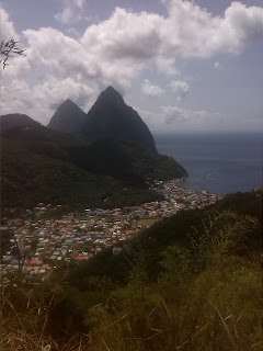
Soufrière, Saint Lucia
| Soufrière | |
|---|---|
| Town | |
Soufrière and the Pitons
| |
|
Political map of Saint Lucia showing Soufrière | |
| Coordinates: 13.854°N 61.0592°W | |
| Country | |
| Quarter | Soufrière Quarter |
| Founded | 18th Century |
| Founded by | The French |
| Named for | The local volcano |
| Government | |
| • Governing body | Soufrière Council |
| Elevation | 5 m (16 ft) |
| Population (2005)[1] | |
| • Total | 7,935 (Soufrière District) |
| Time zone | Eastern Caribbean Time Zone (ECT) (UTC-4) |
| Area code(s) | 758 |
Soufrière is a town on the West Coast of Saint Lucia. The town and the surrounding district has a population of 7,935. Originally founded by the French it was the original capital of the island.[2]
There were large estates run by plantation owners of French origin and their descendants still live in the area. The French Revolution of 1789 resulted in many Royalists being executed and the slaves freed. However, Napoleon reintroduced slavery when he came to power.
The British invaded St Lucia shortly after, but the slaves and French deserters fought them in a guerrilla campaign until 1803 when they were defeated and St Lucia became a British colony. Also, during that time,Castries became the capital of St Lucia.
Over the years, Soufrière has had to deal with hurricanes in 1780, 1817, 1831, 1898 and 1980, a major fire in 1955 and an earthquake in 1991. Many of these events have had to result in the town being rebuilt several times.
Soufrière has some famous inhabitants, the future Empress of France Joséphine de Beauharnais spent much of her childhood in the area, as well as George Charles, the first Premier of St Lucia. When Queen Elizabeth II visited St Lucia in 1966, she landed at Soufrière rather than Castries.
Today, Soufrière is more dependent on tourism rather than agriculture. The Pitons are just south of the town and there are several attractions in the area. Many of the old estates are still there such as Soufrière Estate, Fond Doux Estate and Rabot Estate.


No comments:
Post a Comment